On Wednesday, the NISAR satellite was put into orbit as part of a partnership between the Indian Space Research Organization (ISRO) and the US space agency NASA, with a successful flight of the GSLV rocket.
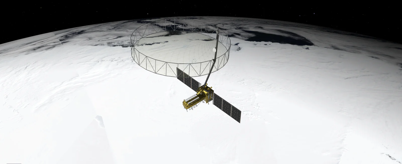
This satellite will chart the earth every 12 days with a 240-km-wide field of radar, offering information to scientists and disaster relief officials to track everything from the melting of Himalayan glaciers to landslide-prone regions in South America.
The NASA-ISRO Synthetic Aperture Radar (NISAR) satellite has been jointly developed by the two space agencies. Although ISRO has put into orbit earth observation satellites like RESOURCESAT and RISAT earlier, the information garnered from those satellites was confined to the Indian subcontinent.
This is the first time ISRO and NASA have jointly launched a satellite that will monitor the entire Earth. ISRO's GSLV F-16 placed the NISAR satellite in a Sun Synchronous Polar Orbit (SSPO) at a distance of about 745 km after a flight of about 19 minutes, marking a successful collaboration between the world's two top space agencies.
ISRO Chairman V Narayanan said, "I am very happy to announce that GSLV F-16 has successfully placed the NISAR satellite in orbit." Wednesday's mission was reportedly the world's most expensive mission, with an estimated cost of $1.5 billion.
It was also the first GSLV mission to a Sun Synchronous Polar Orbit. All GSLV missions so far have been to Geosynchronous Transfer Orbit (GTO). Being a SSPO mission, a lot of analysis and studies were done to make it a complete success.
Narayanan said that the performance of all vehicle systems was normal as expected and as predicted. Today we have achieved the desired orbit. In fact, we have achieved an orbit with a deviation (deviation from the desired orbit) of less than three km as compared to the acceptable level of 20 km...all parameters are as expected.
NASA said that the data obtained from NISAR will provide important inputs to the government and administration in planning to deal with natural and man-made threats. NISAR can help in hazard monitoring efforts and potentially give the administration more time to prepare to deal with a potential disaster.
The NISAR satellite will provide 3-D images of the Earth's land and ice. With its ability to see through clouds and light rain day and night, the satellite will enable data users to continuously monitor earthquake and landslide-prone areas and determine how rapidly glaciers and ice sheets are changing.
According to ISRO, the primary objective of the mission is to study land and ice changes, land ecosystems and marine areas in areas of common interest to the US and Indian scientific community. The mission will help measure biomass, track changes in the extent of active crops and understand changes in water bodies.


%20(7).jpg)


%20(3).jpg)