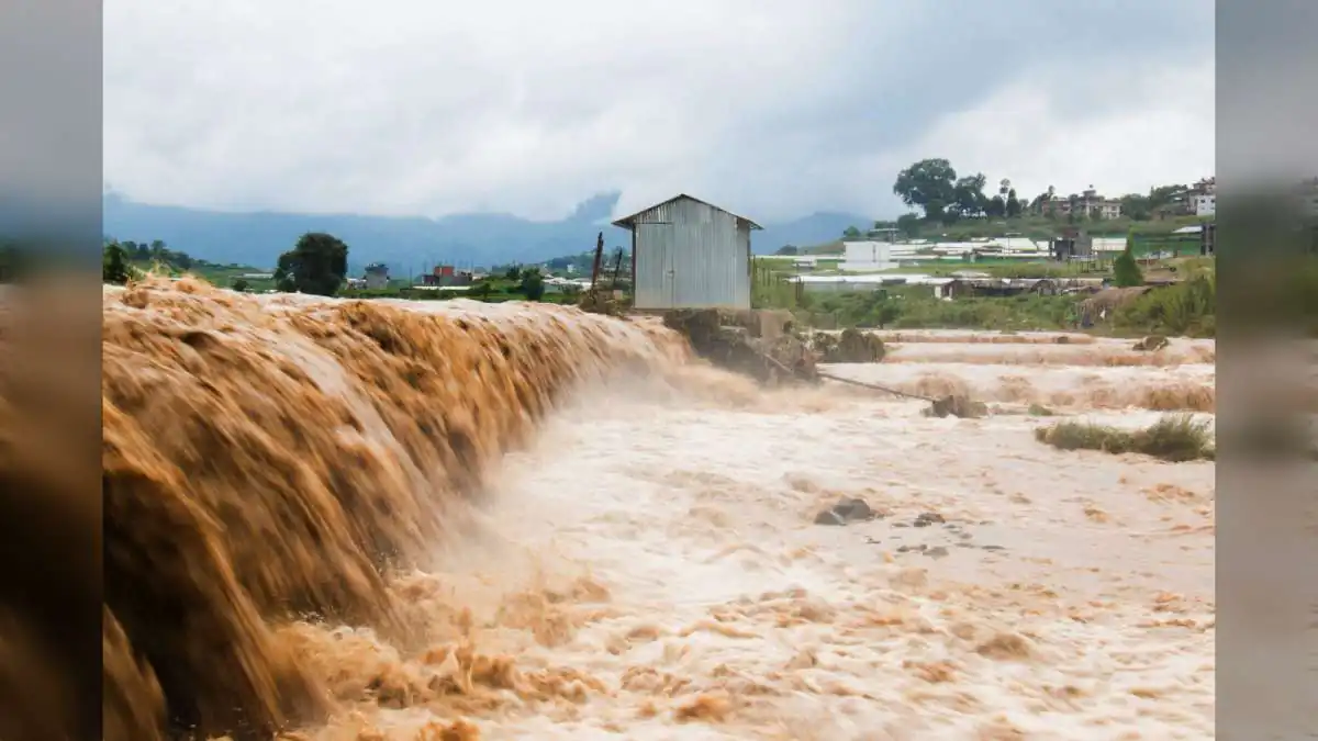
South Asia is once again reckoning with the devastating reality that its rivers, its geography and its geopolitics are inseparable. On Wednesday, widespread death and destruction were reported from Nepal as flash floods in the Bhote Koshi river — originating from Tibet — inundated many areas in districts north of the capital Kathmandu. Reports suggest torrents of water from Tibet surging into Nepal, sweeping away bridges, damaging hydropower plants and inundating villages. It is a scene that captures, in real time, one of South Asia's most enduring — and increasingly dangerous — cross-border stories.
India is not spared. The Kosi River, long known as the "Sorrow of Bihar", is swelling dangerously and threatening millions of lives and livelihoods across the state. Similarly, the mighty Brahmaputra — known as the Yarlung Tsangpo in Tibet — once again overflowed its banks this monsoon, killing at least 50 and displacing some seven lakh people in Assam. Together, these events reflect the fragility of the region's monsoon geography — one that is now being complicated further by human interventions upstream.
The China Dam-Building Concern
At the centre of the growing concern is China's aggressive dam-building programme in Tibet and downstream regions. Studies suggest that this programme is creating a dangerous mix of ecological fragility, geopolitical tension and human vulnerability across South Asia. It is a set of concerns that has been building for over a decade, but has now sharpened dramatically as the scale of upstream projects continues to expand.
The Existing Dam Portfolio in Tibet
China has already built several large dams in Tibet as part of a broader hydropower push. These include the Zangmu Dam on the Yarlung Tsangpo, completed in 2015, and the Jiexu and Jiacha dams, which followed soon after. Each of these projects is officially framed as part of Beijing's energy security strategy — but each also carries implications for downstream water flows, sediment patterns, seasonal availability and cross-border river management.
The Medog Super Dam: A Project That Changes the Equation
The most controversial announcement, however, is Beijing's plan for a super dam at Medog County, near the Great Bend of the Yarlung Tsangpo — precisely where the river makes a dramatic U-turn before entering India. Much of the detailed information about this mega dam remains under wraps. What is known is that it could generate three times the power of the Three Gorges Dam, but its scale raises deep concerns about seismic safety and flood management.
The Numbers That Define Medog
Planned to be the world's largest hydropower project, the Medog (Motuo) Dam is being designed with a proposed capacity of 60,000 MW, at an estimated cost of around 1 trillion Yen — approximately $148 billion. Even by China's own extraordinary scale of infrastructure ambition, these numbers push the project into an entirely new category — one where every kilowatt of installed capacity comes with layers of engineering, environmental and geopolitical complexity.
The Three Gorges Comparison
For context, the Three Gorges Dam on the Yangtze river in Hubei Province — completed in 2012 after nearly two decades of construction — is currently the world's largest hydroelectric power station by installed capacity, producing more than 22,500 MW. It spans more than two km and rises 185 metres high. While it stands as a symbol of China's engineering ambition, the project has long remained controversial for the social and environmental costs it has allegedly imposed. The Medog Dam would dwarf it — with all the amplified risks that scale implies.
Sitting on Seismic Fault Lines
The most serious risk factor associated with the Medog Dam is its location. The proposed site sits in one of the world's most seismically active zones. Sudden releases or failures could devastate downstream regions in India and Bangladesh, while altered sediment flows threaten agriculture and ecosystems across the Gangetic plains. Every element of the project — from tunnelling to reservoir management to sediment control — must contend with this deeply unstable geological reality.
What the ISDP Report Warns
'The Medog Imperative', a 2026 report from the Institute for Security and Development Policy (ISDP), a Stockholm-based non-profit research and policy organisation, has warned explicitly of the project's seismic volatility. "Recall the January 2025 earthquake on the Tibetan Plateau that caused massive damage to human life, ecology, and security. Combined with the political sensitivities surrounding Tibet and China's upper-riparian status, the project raises a series of questions that cannot remain outside the purview of global climate governance, especially the United Nations Framework Convention on Climate Change (UNFCCC)," it warned.
Hydrologists Sound the Alarm
The report goes further, claiming that hydrologists, environmental researchers and geologists have expressed unease regarding the project's feasibility and safety. The region sits along the collision boundary of the Indian and Eurasian tectonic plates — the same tectonic activity that has shaped the Himalayas over millions of years and continues to trigger frequent seismic events in the area.
Downstream Anxiety: India and Bangladesh
The Yarlung Tsangpo flows from Tibet into India as the Brahmaputra and then into Bangladesh as the Jamuna — raising serious concerns in both downstream countries about water security. As highlighted by a New York Times report last year, the Tibetan plateau was formed by the collision of the Indian and Eurasian tectonic plates millions of years ago. To this day, the Indian plate is still slowly moving toward the Eurasian one, which is why the Himalayas are regularly hit by earthquakes. Any major hydropower installation in this zone inevitably places downstream nations in a position of heightened risk.
The 2025 Earthquake and Its Warning
The report noted that Chinese officials confirmed that cracks appeared on five hydropower dams in Tibet after a magnitude 7.1 earthquake struck near the city of Shigatse in early 2025 — an event that killed more than 120 people. That single episode captures precisely what independent experts have long warned — that even well-engineered dams in this geography carry the risk of significant damage in the event of major seismic activity.
Landslides and Mudflows: The Secondary Threats
Even if the Motuo dam is built well enough to withstand an earthquake, the landslides and mudflows resulting from such quakes are difficult to contain and can kill people living nearby. Experts have noted that the massive excavation involved in dam construction could make such disasters more likely — a risk that grows exponentially with the size of the project.
Chinese Journals Themselves Flag the Challenges
Notably, some of the strongest technical concerns come from within China itself. Separate reports, quoting Chinese hydrology and geology journals such as Shuili Xuebao (Journal of Hydraulic Engineering) and Dizhi Kexue (Geological Science), have highlighted the engineering challenges of the Medog project — including tunnelling through permafrost, managing unstable sediment and mitigating seismic risks. A study by researchers at the China Institute of Water Resources and Hydropower Research (IWHR) has reportedly assessed the potential for reservoir-induced seismicity at the Medog site, noting its location at the tectonic collision boundary.
Why It Matters: Cross-Border Rivers, Cross-Border Risks
The Yarlung Tsangpo–Brahmaputra system is one of the world's most important cross-border river systems, sustaining tens of millions of people across three nations. Any upstream intervention of the scale being contemplated at Medog carries direct implications for downstream water availability, sediment flow, agricultural cycles, fisheries, aquatic ecosystems, and human settlements. In this sense, the Medog project is not merely a Chinese domestic infrastructure decision — it is a regional issue with global implications.
The Nepal Dimension
Nepal's experience with the Bhote Koshi flooding this week is a stark, real-time example of how upstream water events in Tibet quickly translate into downstream disasters in South Asia. When large volumes of water are released — whether through natural events or dam-related actions — nations like Nepal, with limited early-warning capacity and vulnerable river-adjacent communities, bear the immediate brunt of the impact.
India's Long-Standing Concern
India has long expressed concerns about the potential impact of large Chinese hydropower projects on the Brahmaputra system. Water flow modifications, sudden releases, altered sediment patterns and downstream flooding risks all have direct implications for Assam, Arunachal Pradesh and the wider North-East. New Delhi has repeatedly raised these issues through diplomatic channels, and continues to closely monitor construction and reservoir activity upstream.
Bangladesh's Vulnerability
Bangladesh, further downstream, faces an even more layered set of risks. As a low-lying country already highly exposed to river flooding, delta erosion and cyclone impact, Bangladesh's water and food security is deeply tied to consistent, predictable Brahmaputra-Jamuna flow patterns. Any large upstream project that alters these patterns can significantly reshape agricultural productivity, freshwater availability and coastal delta stability.
Climate Change: The Amplifier
Compounding all these risks is the accelerating impact of climate change. Glacier retreat in the Himalayas, changing monsoon patterns, more intense rainfall events, and rising temperatures across the plateau are collectively raising water-related risks across the entire region. Every large dam project in such a rapidly changing hydrological environment must be evaluated not just for today's risks, but for the amplified risks of an increasingly volatile climate future.
Why It Matters: The Absence of Robust Data Sharing
One of the most fundamental gaps in South Asia's cross-border water management is the absence of robust, transparent and real-time data sharing between upstream and downstream nations. Without timely information on reservoir levels, water release schedules, seismic activity and construction progress, downstream nations are forced to plan and respond blindly to a river system whose behaviour is being continuously reshaped upstream.
The Case for Climate-Resilient Water Management
Some experts have suggested a wholesale shift in how water infrastructure is designed and deployed in this fragile region. Rather than mega-scale, high-risk hydropower projects, the argument favours smaller, adaptive projects, robust early-warning systems and transparent cross-border data sharing. This approach — more distributed, more community-focused, more climate-aware — would better align with the seismic realities and monsoon vulnerabilities of the region.
Industry Impact: Rethinking Hydropower Scale
The Medog Dam controversy also raises deeper questions for the global hydropower industry. It challenges the assumption that bigger is inherently better in energy infrastructure. Modern engineering, environmental science and geopolitical realities all suggest that in seismically active, ecologically sensitive, and geopolitically complex regions, smaller and more decentralised projects may deliver stronger long-term outcomes than mega dams.
The Global Governance Question
The ISDP report's call for such projects to fall within the scope of the United Nations Framework Convention on Climate Change (UNFCCC) is significant. It reflects a growing global recognition that transboundary hydropower projects — particularly those in ecologically sensitive zones — carry implications that extend beyond national borders. A structured global governance framework for such projects could help ensure that risk assessment, mitigation planning and stakeholder consultation happen at the scale the projects themselves demand.
Audience Sentiment: Concern Across the Region
Public sentiment across South Asia — in India, Nepal, Bhutan and Bangladesh — around China's expanding hydropower footprint in Tibet has been steadily deepening. The combination of visible downstream flooding events, opaque construction timelines, seismic warnings and geopolitical tensions has created a distinctly anxious backdrop against which every new announcement is now received.
Why It Matters: The Human Cost Is Real
Behind all the geopolitical and engineering discussions lie the very real human costs of water-related disasters. Every displaced family in Assam, every damaged bridge in Nepal, every submerged farmland in Bihar and every lost livelihood in Bangladesh represents a human story of loss and disruption. Any policy conversation about upstream dams must ultimately centre these human realities — not treat them as secondary consequences of decisions made elsewhere.
The Bigger Picture: A Region at a Crossroads
South Asia stands at a critical crossroads in its water future. The combination of climate change, rapid population growth, urbanisation, industrialisation and cross-border river dependence means that the region must urgently invest in cooperative, science-based, transparent water governance frameworks. Without such cooperation, individual national actions upstream will continue to translate into unpredictable disasters downstream — and the cycle of vulnerability will only deepen.
What to Watch: Diplomacy and Data
Going forward, several developments will shape South Asia's response to the emerging water risk landscape. These include the pace and transparency of the Medog project's development, the strength of diplomatic engagement between China and downstream nations, the extent to which multilateral platforms take on water governance questions, and the willingness of all stakeholders to embrace open data sharing as a foundation of regional trust.
The Bigger Picture: Rivers Do Not Recognise Borders
At its heart, this is a story about a simple but profound truth — rivers do not recognise political borders. They flow where geography sends them, carrying water, sediment, opportunity and risk across nations, cultures and communities. Every attempt to control, dam or divert them must therefore begin with a deep respect for that shared reality — and a commitment to shared responsibility for the outcomes.
The Bottom Line
The floods in Nepal's Bhote Koshi, the swelling of Bihar's Kosi and the destruction wrought by the Brahmaputra in Assam are all part of a broader, deeply interconnected South Asian water story — one where China's aggressive dam-building programme in Tibet is adding a new and troubling layer of risk. The proposed 60,000 MW Medog super dam, sitting on one of the world's most seismically active zones, represents both the most ambitious and the most consequential expression of that programme so far. As global experts, downstream nations and international institutions raise warnings about seismic vulnerability, ecological fragility and geopolitical opacity, one message emerges with unmistakable clarity — South Asia's water future can no longer be managed as a series of isolated national decisions. It must be managed as a shared responsibility. The rivers that connect Tibet, India, Nepal and Bangladesh are more than energy resources or engineering challenges. They are lifelines of civilisation. Protecting them, respecting them and governing them wisely is no longer a matter of choice. It is a matter of survival. And how the world responds to the growing risks posed by upstream mega dams like Medog will, in many ways, define whether South Asia enters the coming decades as a region of shared water security — or of shared water disaster.















































.jpg)